How to find water for a well: a review of effective methods for finding an aquifer
Drilling a well on a country plot will provide its owners with the water required for personal purposes and irrigation.Our own source will allow us to build an independent water supply system. However, there are cases when excavation excavation does not produce results. How to avoid such “mistakes”? After all, the drillers will have to pay, even if there is no water.
We will tell you in great detail how to find water for a well. We will introduce you to all possible methods of searching for this mineral. Let us present technologies used on an industrial scale and traditional methods for determining the availability of groundwater.
To thoroughly study the topic, we have collected and systematized noteworthy information available on the Internet. The information presented for consideration is supplemented with photographs, graphic illustrations and video reviews.
The content of the article:
The simplest classification of groundwater
Before you start searching for water for a well, you should record the presence of such underground resources and determine the depth of the aquifer in the selected area.
Depending on the location and depth of occurrence, groundwater is divided into three types:
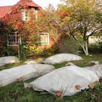
- Verkhovodka – lies within 2-5 meters from the surface. It is formed as a result of the filtration of atmospheric precipitation. Due to its shallow occurrence, this type of water can fluctuate: it sometimes rises after precipitation, then decreases during the dry period.
- Groundwater – aquifers in sedimentary rocks, located approximately 8-40 meters from the surface. They are protected from above by several layers of rock, so they do not depend on the changing seasons. Sometimes, in depressions of the relief, they independently make their way into springs that supply tasty, clean water.
- Artesian waters – most often occur at a depth of over 40 meters. They are distributed along cracks in rocky limestone. The water is characterized by the presence of mineral salts and the absence of clay suspension. The flow rate of artesian wells is quite stable.
The qualitative and quantitative parameters of the aquifer are of key importance.

When searching for water well development You can use different methods, both using improvised means and using modern technology. But most often, hydrogeologists use the preliminary exploration method to search for an aquifer and determine its depth.

Preliminary exploration of the deposit
The easiest way to calculate an aquifer is based on geotechnical research. A geological section will help clarify the picture, displaying the structural features and demonstrating the sequence of bedding of rocks above the deposit.
At the stage of preliminary exploration, two tasks are solved at once:
- The hydrogeological conditions of the site are being studied.
- A qualitative and quantitative assessment of the source used is carried out.
Services of this kind of research are provided by organizations engaged in engineering geology and hydrogeology, specializing in well drilling.

On the most promising for water intake device In areas identified as a result of preliminary exploration, engineering and geological features are subsequently studied: land subsidence, the likelihood of landslides, drillability categories of the rock being exposed, the nature of its stability in the well...
Large-scale hydrogeological survey can be used as a working method. During the detailed survey, aquifers are mapped and the composition and reserve of groundwater is determined. Based on the data, you can decide on the feasibility well drilling on the site, at the same time find out at what depth the water will be.
For well-studied areas where there is already experience in the exploitation of underground sources, the assessment of water supply can be carried out based on the degree of confidence of category C2. Prospective reserves of this category are calculated on the basis of geological and geophysical data from explored deposits whose occurrence conditions are similar.
Electrical sensing method
To identify promising areas for water, the method of electrical probing is most often used. It is carried out by vertical probing of the soil. The electrical resistivity of rocks and underground aquifers varies.
Thus, water-saturated soils have a lower electrical resistance than the mineral skeleton of low-moisture rocks.

The only drawback of this method is that there is always a possibility of calculation errors if there are iron ore deposits in the ground or the proximity of metal fences and railway networks.
Seismic technology
The seismic exploration technique is based on measuring wave kinematics. Using instruments, places are determined where there is an increased seismic background, the peak values of which reach frequencies from 4 to 15 Hz.
The essence of seismic exploration is that the measurements are first carried out in an area located in close proximity to the groundwater search site, which has a similar geological section.
The downward generated waves, having reached the rock, which differs from the overlying layers, are reflected upward, like an echo. Then, within an hour, the same measurements are carried out in the area where groundwater is being searched.
The depth of the reflecting boundary is calculated based on the obtained values of the sensitive devices of geophones. The presence of artesian waters is judged by a 5-10 times increase in the level of seismic background in the area of the study areas.

When acoustic waves pass through liquids that have a high density, a change occurs towards higher frequencies.
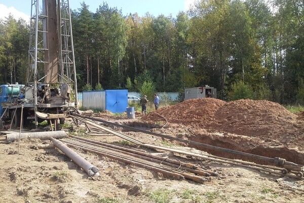
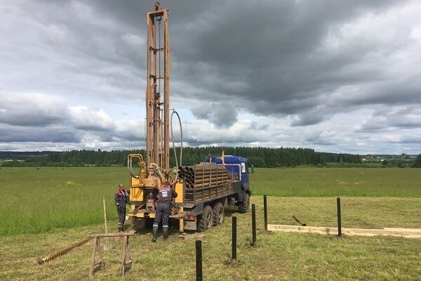
Exploration drilling
This method allows you to most accurately determine the geological rocks forming the site. But since it involves large financial costs, it is used only in situations where it is planned to equip a large water intake designed for several houses.

Experts distinguish three methods of exploration drilling:
- Core – used when drilling to great depths. The principle of operation is based on the fact that a rotating core pipe, the end of which is equipped with a drill bit, cuts through the rock.And then the destroyed rock, under the pressure of the washing solution or compressed air supplied through the pipe column, is pushed to the surface.
- Rotary – is based on the transmission of rotational motion to the drill string through a surface rotor. This type of drilling is accompanied by flushing the rock face with a special solution or ordinary water.
- Shock-rope – works due to the destruction of rocks under the action of a falling drilling tool, the end of which is fixed to a rope. The tool simply breaks off the rock and crushes the soil, and then uses a bailer to extract it to the surface.
Selecting a drilling method and drill bit depends on the type of rock, the depth of the formation or lens and the financial capabilities of the customer. But in terms of drilling speed and productivity, rotational methods win in this regard.
The price of an exploration well is determined by multiplying the cost of one linear meter by the depth of the wellbore. The total amount is calculated based on the complexity of the excavation, the diameter of the trunk and the need to use casing pipes.
Hydrogeological data obtained from drilled wells is taken into account when preparing a forecast assessment of the prospective area. They help to study changes in the properties of water-bearing rocks in a vertical section.
Drilling a well with your own hands
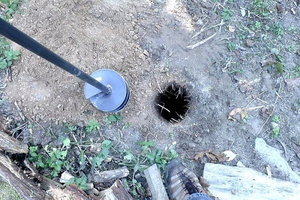
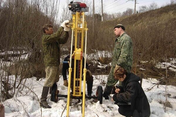
But drilling exploratory wells is a rather expensive method. Not many owners of suburban areas can afford it. As an alternative, test drilling can be done independently using the auger method.
This method is similar to making a hole in the ice during winter fishing. The screw-shaped structure is simply screwed into the ground.When extracted to the surface, the auger blades take the crushed rock with them.

To carry out the work, you will need an auger with blades equipped with a drilling head. You can purchase such a screw tool at any hardware store. It comes complete with stacking rods, which are convenient to use to build up the structure as it goes deeper into the soil.
The work is performed in the following sequence:
- In the selected area, dig a guide hole 60-80 cm deep.
- The auger is lowered into the hole and begins to rotate, deepening the drill head.
- After the screw rod has gone 1-2 meters deep into the soil, the drill is removed, removing the loosened soil. As the helical structure advances, it is important to ensure that the well is vertical.
- When the auger reaches a depth at which it is no longer convenient to work with the tool, the structure is expanded with a drill rod. Simultaneously with drilling, the walls of the well are casing under the influence of centrifugal force.
- Drilling is carried out until the screw rod reaches the aquifer.
The excavated soil is transported using the same auger, which is a single screw conveyor, to the surface. At the same time, the soil raised outward strengthens the walls of the trunk due to friction. This reduces costs when drilling plastic soils, since there is no need to use casing pipes.
But it is worth considering that the auger method is effective only when searching for groundwater, the level of which does not exceed 50 meters, and the rocks belong to the plastic and loose category.
Traditional methods of determination
Carry out exploration on your own in search of an aquifer for shallow excavation drilling or needle wells are possible, even if there are no landmarks in the adjacent areas.
Orientation based on natural features
Signs of the presence of an aquifer in the soil can be:
- Observing the behavior of animals and insects. Columns of midges hover in the place where there is a source of water, and red ants, on the contrary, try to settle away from it.
- There is a wide distribution of moisture-loving plants in the area.
Indicators of the proximity of groundwater from herbaceous plants are nettle, horsetail, sedge, sorrel, and reed. Tree-like plants with a tap root such as bird cherry, willow, birch, black poplar, sarsazan will indicate that the water lies at a depth of up to 7 meters.

The soil and underlying rocks, under which the spring passes, are characterized by increased humidity. It will certainly evaporate, forming clouds of fog in the morning; you just need to observe the area.
Pay attention also to the relief. It was noticed that the water carriers lie almost horizontally. Therefore, in the area of depressions the probability of water occurrence is always higher.
Using dowsing frames
The ancient method, based on the dowsing effect, in which a person reacts to the presence of water and other bodies in the ground that create heterogeneities of various configurations and sizes in its thickness, does not lose popularity.
When searching for water to choose a place for water well At the site, the dowsing indicator is a wire frame or a tree branch with a fork, which is in the hands of a human operator. It is able to determine the presence of an aquifer, despite even the layer of soil separating it from the water.

Dowsing frames can be made of calibrated aluminum, steel or copper wire with a diameter of 2-5 mm. To do this, the ends of pieces of wire 40-50 cm long are bent at right angles, giving them an L-shape. The length of the sensitive shoulder will be 30-35 cm, and the length of the handle 10-15 cm.
The operator’s task is to ensure free rotation of the “tool”. To make the task easier, wooden handles are placed on the bent ends of the wire.
Having bent your arms at a right angle and taking the tool by the wooden handles, you need to slightly tilt them away from you so that the wire rods become like an extension of your arms.
To achieve a goal, you need to consciously tune in and clearly formulate the task for yourself. After this, you just need to slowly move around the area and watch the rotation of the frames.
In the area where underground water is hidden, the frame rods will cross each other. The operator must mark this point and continue research, but moving in a perpendicular direction relative to the original line of movement. The desired source will be located at the intersection point of the found marks.

It is believed that the best time to search for water by dowsing is summer or early autumn.The most favorable periods:
- from 5 to 6 am;
- from 16 to 17 days;
- from 20 to 21 pm;
- from 24 to 1 am.
L-shaped frames are convenient to use in field conditions, but in the absence of wind. To work with the tool you need experience and dexterity. After all, frame deviation can even depend on the emotional state of the operator.
For the same reason, it is better to refrain from drinking alcoholic beverages before working with frames. Before you start searching, you need to learn how to work with a biolocator and “hear” it. Thanks to this, in the process of searching for water for a well, the operator will not be distracted even by the presence of closed water pipelines in the area.
But it is worth noting that traditional methods cannot provide a 100% guarantee of obtaining the expected result. After all, even with a successful outcome, there is always a risk of getting water well with low productivity.
Conclusions and useful video on the topic
Tips for beginners on how to determine the location for a well and drill it with your own hands:
Exploration drilling using a probe:
Such a responsible event as searching for water for a well should be approached with all seriousness, using modern exploration methods for this purpose, or entrust this work to professionals.
Would you like to tell us how you chose a place to drill a well on your own property or ask a question? Please write comments in the block below. Here you can discuss with us and with site visitors if you do not agree with the information presented.


Recently I planned to drill a well under water, because... carry water home far. In addition, it takes a lot of time, and there are a lot of inconveniences. But this is not a cheap idea.To avoid getting into trouble, I obtained information about the occurrence of water from a local drilling company. Although before that I relied on the folk method, saying that where burdock grows, there is water. But it turned out quite the opposite. I recommend to everyone, do not reinvent the wheel - find out information from specialists.
I'll argue with the previous comment, and here's why. I also didn’t trust traditional methods. But after the mother-in-law correctly identified the place for the well in her house, she changed her mind. She did this with the help of willow.
It is believed that willow is very sensitive to water. She used a willow branch with two ends (like a slingshot). I didn’t make a slingshot, but rather so that the branch itself had this shape. The length of the ends is 15-20 cm. I held the two ends with my hands, and the thick end forward. In the place where there was water, this end began to slope down. It is advisable to hold the branches not with your hands, but to insert them into some kind of holder. In our case, it was a ballpoint pen housing.
Dear Natalia. Your statement is complete nonsense. You simply don't represent the area of the aquifer in a plan. Believe me, this is much more than several square kilometers, most often tens and hundreds of km². And you and your mother-in-law walk around the property with a twig, as if looking for a jar of gold. If you think that your water really is at one point, then why drill a well to extract it? You will pump it all out at once.
The aquifer is either completely under your dacha area, or it is not there, i.e., most likely, it lies at too great a depth.What is there to look for on six hundred square meters with a slingshot? Go to your neighbors, find out if they have a well or well, at what level the water is, and order drilling, choosing a location that is CONVENIENT for subsequent exploitation.
Dear Alesya. You're right, but not entirely. I myself am engaged in drilling and searching for water using dowsing. The fact is that the surface of the earth, as well as aquifers, are not smooth like a hen’s egg, but as a result of the movement of the earth’s crust and glaciers, as well as many other reasons, they have acquired the shape of, say, wrinkles. And just like on the human body, sweat appears all over the surface, but the drops flow down precisely along these wrinkles, which many drillers call water veins.
And any movement (human, electricity, wind, water...) creates electromagnetic waves, which affect the frames or vines. That's why I don't take on wells unless I find such a vein. Since there is either little water in this place, or it lies at great depths.
Dear Peter! You are completely wrong, about absolutely nothing. Please don’t search for water using dowsing, don’t fool people.
What are the “wrinkles” in aquifers? Wells for private owners are drilled in the quarter. These are sedimentary deposits that “settled” on the ancient terrain for billions of years. Everything there is approximately horizontally oriented with slight deviations.
What the hell is vein water?! Is this gold, or what? Groundwater occurs in only two forms: it occupies pores and voids in Quaternary sands/pebbles/gravels or condenses in cracks formed in rocks. All.
Alesya, a specialist worked at my site.At the place where my grandfather had an old well, of which there had been no trace for many years, a man with a frame said that the water here was salty (my grandfather confirmed that this was the case - the well was filled in because of the salt in the water). After which a place was found: “here the water is good and there will be no end to it.” As a result, the water in the well is really good and you can pump it for at least a day.
This is what they are, these aquifers and the wonderful science of geology. By the way, my neighbor at the same depth has quicksand instead of an aquifer.
Another case, in the village of Lvov, Rostov region, Oryol district, there were old wells. They were digging them even before the war. There was not enough water - geologists arrived (this happened in the 80s). They drilled, drilled, sand and tyrsa for more than 100 meters. So they never found water. Then in the 2000s they discovered water and made a well. And those wells still have water.
Pavel, I apologize in advance for the harshness of my words, but you can’t be so dense in the 21st century!
Which specialist with the frame? You could also call a shaman with a tambourine - he would tell you no less “about the secrets of nature.” And I also read some spells. What are you doing? All these flyer frames are for uneducated people to make more money from them. Think about it, what if this “specialist” just has a hangover and his hands are shaking, and you’ll start drilling where his tremors appear?
All these tricks with frames have long been refuted. But they are still trying to use dowsing to look for karst cavities in rocks in the middle zone. It's just that the difference in density in the upper layers of the crust can actually be detected. It is not a fact that they contain water. These types of “technologies” have nothing to do with hydrogeology at all.
And yes.Did you dig a well with salt water? With mineral? On your site? Or they could just get rich from its spoils) Unless, of course, someone “made a joke” on your grandfather in such an evil and stupid way.
Tyrsa 100 m from the surface? Someone filled up your mountains there, or what? It must have been when the Black Sea was being dug that the dump was taken to your village :)
Water is not gold, it is everywhere. On private plots of 6 acres, it is everywhere at approximately the same depth, there may be a difference of 10 cm. You just need to choose the most convenient place for drilling a mine and its subsequent operation. If you had a plot of 100 hectares, you could, for your own peace of mind, walk around with frames and a smart look, pretending that you were looking for something. But on such a piece of land it makes no sense.
Well, I do not. Now every house has a well. In one village, some had water at 5 meters, and some at 20. Moreover, some drilled more than one well on their several hundred square meters. Because here they didn’t find any water at all, but here it turned out to be shallow.
Pavel, tell me, is it possible to somehow get around the quicksand? The fact is that we have already drilled a well on the site for the 4th time and it’s all in vain - we reach 15-20 m and the quicksand sucks everything in.
Even the casing pipes don’t go any further, we just give money to people for their work and that’s it! What's the most effective way to find water? Please tell me!
The best way to avoid quicksand is to not drill in its location. I’m just wondering how you chose a place for a water well if you hit quicksand for the fourth time?
If the place for the well is chosen by the same people who drill it, then it’s not your problem that they hit quicksand for the fourth time! You should pay for the actual work done, not for the number of failed attempts. It looks like people are taking advantage of your incompetence and are trying, excuse me, to scam you out of money.
I work in this field and such “specialists” are rare, but they do occur. I also encounter quicksand, but very rarely; we have our own methods for dealing with them and passing this section. So far there has been no quicksand that would force us to drill a new well.
Hello. Maybe you can tell me something useful... Because my site collected everything: quicksand, and a swamp at 9 meters, and at 15 meters the installation simply could not break through some layer (dolomite), as the driller said. There was something black along the way (I jokingly said it was oil). I’m waiting for more specialists... already 3. They say that they will definitely drill through everything with their installation, but there is a possibility that the contents from the swamp will fall into the lower layer through the space between the pipe and the rock.
We walked with a wire)) AS THEY SAY, ALL METHODS ARE ALREADY GOOD. Where they drilled - nothing, in several places they actually interbreed... I checked it 5 times... What can you advise, where to look and what to drill with? And what could it be?
Another thing from my observations is that there seems to be a drop in the area - I think these are the so-called quicksand boundaries, but maybe I’m wrong. There is a river and wells nearby. Thank you in advance.
Let's try to understand the situation. Regarding how to get around quicksand, as I wrote above, there are ways:
1. Impact-rope method, when they drill with a special impact machine inside a metal pipe;
2.Abyssinian well - this method involves driving a pipe from the surface, diameter 2.5 cm, to a depth of 20 m.
Now about the black liquid. Since you write that there is a swampy area nearby, most likely these are silt deposits that have entered the groundwater, for example. Their danger is that they can clog the water in the well. But again, the casing is made in the well to avoid the entry of this kind of contaminants.
About dolomite. It’s not a problem to drill it, you need three things: a drill, experience and time. It’s just that now many people have put their business on hold, everyone wants to make a well in a day, get money and goodbye. And sometimes you have to drill dolomite at a speed of 1 m in 4-6 hours. Personally, I have never had such a situation where our team came to drill, stumbled upon a boulder, quicksand, dolomite, etc., we declared that this was impossible and folded. Look for normal specialists who will give you the result in the form of a finished well!
Hello. I will speak out regarding dowsing. In fact, this is as effective as calling a water magician and asking him to look for aquifers. You can even take 3 dowsers with experience, put them in one area, and all 3 will show different points.
Organizations like “horns and hooves” offer the services of experienced dowsers, but even there they say that the success rate of such an event is 50%. That is, an accident. There is nothing scientific about this method.